HOW WE DO CROP ESTIMATES
As in any free market, supply and demand play a very important role in setting the price for products. Crop estimates provide the supply side of the market and are used by SAFEX to determine the price of grain.
Crop estimates are announced on a monthly basis by the Crop Estimates Committee (CEC) of the Department of Agriculture, Land Reform and Rural Development. The CEC bases their estimate on the input of various stakeholders, but in 2006 the Producer Independent Crop Estimates System (PICES) was accepted as the benchmark for all area estimates in South Africa.
Through the CEC a tender was awarded for the development of a statistical based system to determine the total production of grain in the country. The tender was awarded in 2002 to the National Crop Statistics Consortium (NCSC) consisting of the Agricultural Research Council, Geoterraimage and SiQ.
As part of the NCSC mandate to continuously improve the system, it was necessary to develop a system that could function independently from the producer, in order to be more objective. This has led to the development of PICES in 2005. Implemented after a successful pilot study conducted in Gauteng province, PICES uses crop field boundaries digitized from satellite imagery with a point frame sampling system to objectively estimate the area planted with grain crops. It is important to note that PICES is used only to do an estimate of hectares planted. Later in the specific season an objective yield survey is done by the Agricultural Research Council to objectively determine the yield per hectare.
The steps that are followed during the PICES process, can be summarized as follows:
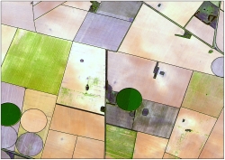 Delineate all potential field crop boundaries from satellite imagery through a process called digitising. Field boundaries have been digitised in all provinces in South Africa – a total of more than 12 million hectares.
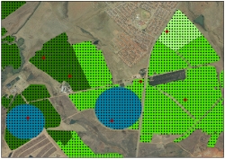 In the next step, sample points are randomly selected to be surveyed in the field. A point grid of 45 meters by 45 meters is set up for the total provincial area. Grid points located outside field boundaries are removed from the sample population. Digitized fields are stratified based on the probability of finding a crop of interest; for instance, high, medium, and low cultivation and pivot irrigation. Stratification is done to increase sampling efficiency and thus reduce costs. More sample points are used in strata where there is a higher likelihood of finding crops of interest.
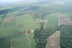 An aerial survey of the sample points is conducted. This aerial survey determines which crop is planted in the field represented by each sample point. These surveys are conducted by a field observation team that consists of a pilot and an observer in a helicopter. The observer is from the agricultural community and is very experienced at distinguishing between different crops and differentiating between dry land and irrigated cultivation. The field observer notes which crop is planted at the sample point and whether it is dry land or irrigated cultivation. Additional information, such as water damage, is also captured. In addition to the data that is being captured, the observer also takes photos to provide more information on the conditions in the field during the specific survey.
During the summer production season, PICES is done for 6 provinces, namely Free State, Gauteng, Mpumalanga, KwaZulu Natal, North West and Limpopo. During the winter season, Free State and the Western Cape is done.